





Tripoli Street is a major road corridor in Dubai that connects Sheikh Mohammed Bin Zayed Road (E311) with Emirates Road (E611). The upgraded corridor stretches for about 12 kilometres and provides an important road link through eastern Dubai, particularly around Mirdif and Al Warqa’a.
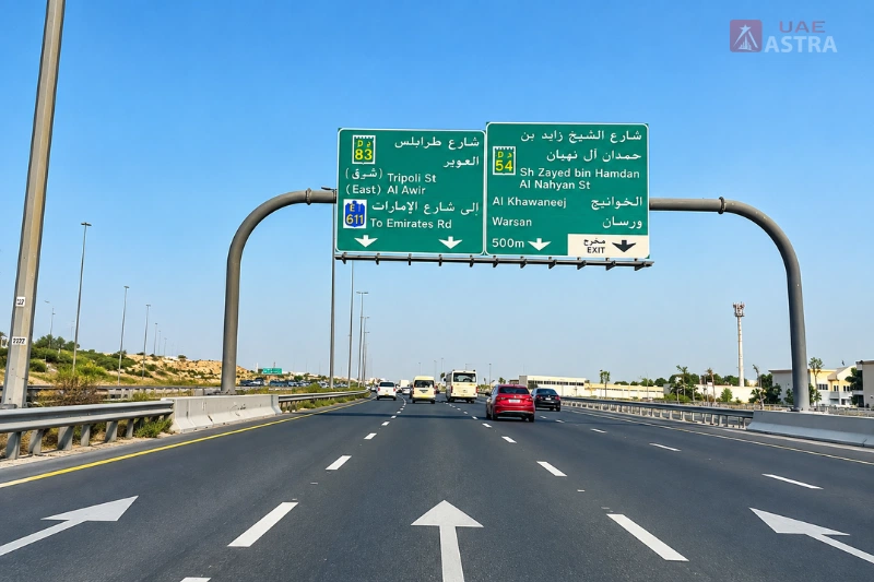
The road is also referred to as D83. It is important due to the number of major roads and crossroads that it joins, such as Sheikh Zayed Bin Hamdan Al Nahyan Road, Nouakchott Street, Algeria Street and Emirates Road. This route was designed to enhance traffic flow between Dubai and Sharjah and serve as an alternative route for motorists using this area of Dubai.
Tripoli Street at a Glance
Tripoli Street is really seen as a 12-kilometre motorway link between two significant highways in Dubai. The western part starts from the Sheikh Mohammed Bin Zayed Road intersection, around Mirdif and heads towards Emirates Road, the extended part.
The road is very significant to those who use it to travel around Mirdif, Al Warqa’a, Muhaisnah and into Emirates Road. It has better intersections in the form of tunnels, flyovers and bridges that facilitate the easier flow of traffic through key intersections rather than using only the traditional roundabout and signal-controlled traffic.
| Detail | Information |
| Road name | Tripoli Street |
| Road number | D83 |
| City | Dubai, UAE |
| Approximate corridor length | 12 km |
| Western connection | Sheikh Mohammed Bin Zayed Road |
| Eastern connection | Emirates Road |
| Key areas | Mirdif, Al Warqa’a, Muhaisnah and surrounding areas |
| Major highway connection | E311 and E611 |
The Route of Tripoli Street
The existing street was improved and extended in the current Tripoli Street corridor. RTA doubled the length of Sheikh Mohammed Bin Zayed Road, with 6.5km between Sheikh Mohammed Bin Zayed Road and Sheikh Zayed Bin Hamdan Al Nahyan Road and extended another 5.3km from Sheikh Zayed Bin Hamdan Al Nahyan Road to Emirates Road. The sections make up the length of the approximate 12-kilometre corridor.
The western end is near the Mirdif City Centre, with the road network linking to Mirdif and Al Warqa’a, continuing to the east where it joins the road network at the eastern end of Emirates Road. This layout allows E311 and E611 to be accessed by motorists without having to rely on any one main north-south corridor on Tripoli Street.
Key Roads Connected to Tripoli Street
The importance of Tripoli Street is primarily based on its links with other significant roads. To enhance the corridor, RTA’s improvement project upgraded several major junctions along the road, including Tripoli-Algeria Street, Tripoli-Nouakchott Street, and Tripoli-Sheikh Zayed Bin Hamdan Al Nahyan Street. The east end also bridges the long road onto Emirates Road.
These are connections that allow Tripoli Street to play a larger part than a local road, serving some of the surrounding communities. Drivers may use it as part of trips using Sheikh Mohammed Bin Zayed Road, Sheikh Zayed Bin Hamdan Al Nahyan Road and Emirates Road and the nearby local roads give access to residential areas to the east and west of the road.
Sheikh Mohammed Bin Zayed Road
The western end of the improved Tripoli Street corridor is Sheikh Mohammed Bin Zayed Road/E311. The project expanded the current section of Tripoli Street from here towards Sheikh Zayed Bin Hamdan Al Nahyan Road, enhancing the highway’s capacity and its links to the rest of the Dubai highway network.
This connection is especially significant for Mirdif as the Western end of the project is in proximity to Mirdif city centre. RTA said specifically that the project is to enhance access to Mirdif and Al Warqa’a along the corridor.
Sheikh Zayed Bin Hamdan Al Nahyan Road
The improved corridor is demarcated by Sheikh Zayed Bin Hamdan Al Nahyan Road in the center. Tripoli Street was extended from this point to Emirates Road, thus forming the second leg of the 12km route. The junction was also improved by RTA to become a flyover to offer free traffic in all directions.
This junction is therefore very significant when taking the full Tripoli Street route. It divides the much-expanded original part of the building from the newer addition towards Emirates Road.
Emirates Road
Emirates Road (E611) is connected to the eastern end of Tripoli Street. RTA constructed a three-lane crossing to enable traffic to move from Tripoli Street onto Emirates Road towards Sharjah, as well as a surface intersection for traffic accessing from Sharjah.
The connection is among the primary justifications for the significance of the road for Dubai-Sharjah traffic. The finished corridor will provide a direct link between E311 and E611 via the Tripoli Street route for motorists.
Mirdif and Tripoli Street
One of the areas that is most closely linked to Tripoli Street is Mirdif. The western part of the road begins near Sheikh Mohammed Bin Zayed Road in Mirdif and enhanced connections with Mirdif were one of the project’s benefits listed by RTA.
The road is also connected to other areas of City Centre Mirdif. Tripoli Street is a key route that links to the wider E311 network close to this area, making it an important approach for motorists travelling to and from Mirdif. This is not a street within a street, but is more about access and connectivity.
Al Warqa’a and Tripoli Street
Another important site that is linked with the Tripoli Street corridor is Al Warqa’a. The junction between Tripoli and Algeria has been upgraded as part of the road project to serve the Al Warqa’a-Mirdif area. The improvement was aimed at reducing waiting time at the intersection and facilitating access to Al Warqa’a and Mirdif, the authority said.
Tripoli Street also constitutes a larger network of roads around Al Warqa’a’s residential areas. The road works undertaken by RTA as part of its internal-road programme clearly identify Tripoli Road as the northern boundary of the area covered by the road works, demonstrating the strong link between the main road and the local street network.
Muhaisnah and the Surrounding Road Network
Tripoli Street also runs through a road system to serve the Muhaisnah area. The improvement work involved modification at two sites in the Muhaisnah area, in which the existing roundabouts were replaced by signalised junctions. In addition, RTA widened the road at various points on Tripoli Street.
These changes were one of a series of measures intended to enhance traffic flow along the whole corridor, not just focused on the two highway connections. This has resulted in several re-routed portions of the road being designed to accommodate more direct motorist movement, as well as increased traffic levels.
What the Tripoli Street Improvement Project Changed
The improvement of Tripoli Street had a major impact on the capacity and junction design of the road. The existing 6.5-kilometre section was widened by RTA and a new 5.3-kilometre road with three lanes in each direction was built between Sheikh Zayed Bin Hamdan Al Nahyan Road and Emirates Road.
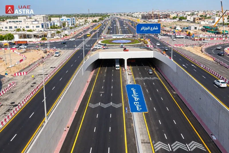
The project also improved the crossing of the most critical intersections. The Tripoli-Algeria junction has been turned into a tunnel with 3 lanes in both directions, the Tripoli-Nouakchott junction upgraded to a 3-lane flyover, and the Tripoli-Sheikh Zayed Bin Hamdan Al Nahyan junction into a 3-lane flyover. There was also the construction of a three-lane bridge at the Emirates Road connection.
The changes aimed to minimise delays due to crossings and traffic turning. The completed corridor is designed to accommodate around 12,000 vehicles an hour in both directions, or 6,000 vehicles an hour in each direction, RTA reported.
Tripoli Street and Dubai-Sharjah Connectivity
Tripoli Street has a specific role in improving the connection between Dubai and Sharjah. The corridor was built by RTA as an extra transportation path in addition to other major corridors in the area such as Al Amardi-Al Khawaneej and Al Awir-Ras Al Khor.
At the time of project opening, the RTA was hoping for a total travel time of approximately eight minutes between Sheikh Mohammed Bin Zayed Road and Emirates Road via the new improved corridor, based on the anticipated traffic levels during the project. It also envisioned a 64% reduction in travel time between Sheikh Mohammed Bin Zayed Road and Sheikh Zayed Bin Hamdan Al Nahyan Road. These are performance estimates for this project period, not defined journey times for each existing journey.
The key takeaway from the practical perspective is that Tripoli Street provides drivers with a new road to travel across eastern Dubai. Actual travel times will still vary with traffic and time of day, road incidents and destination.
Traffic Capacity and Road Performance
The design of the improved Tripoli Street corridor was customized to allow a much increased flow of traffic on the street than was originally provided. The project information provided by the authority states that it will have a capacity of approximately 12,000 vehicles an hour in both directions. It was also looking to redirect a 2,000 vehicles-per-hour traffic flow from Sheikh Mohammed Bin Zayed Road to Emirates Road during peak hours.
The project also aimed to reduce the wait at the Tripoli-Algeria intersection, which is currently taking approximately 3 minutes, to less than 1 minute. These statistics are part of the reason the project concentrated on upgrading the junctions themselves and not just the road itself.
Recent Road Development Around Tripoli Street
Dubai’s overall road development initiative continues with Tripoli Street. In 2025, the RTA announced a project that includes 15 kilometres of new roads, of which 4 kilometres are an extension of Tripoli Street opposite the area and 11 kilometres are internal roads. The project will be finished in the third quarter of 2026.
The Wadi Al Amardi works are expected to help facilitate access to the area, benefit over 30,000 residents and expand the capacity of its entry and exit points, the RTA stated. This is an independent project from the initial 12-kilometre Tripoli Street project, but it does indicate that the Tripoli Street corridor continues to be a part of Dubai’s road expansion plans.
Pedestrian Access Along Tripoli Street
Tripoli Street is mainly a major vehicle corridor, but pedestrian connectivity is part of the broader plans for Dubai. A pedestrian bridge on Tripoli Street between Al Warqa’a and Mirdif is proposed in the Urban Walkways Master Plan by RTA. The plan is part of a programme of 110 pedestrian underpasses and bridges throughout Dubai.
The pedestrian bridge therefore does not justify considering the entire roadway as a pedestrian street. The planned bridge would enhance the safe movement between Al Warqa’a and Mirdif for people walking.
Tripoli Street as D83
The road is often referred to as D83 in road and mapping data. The D83 designation is used to differentiate Tripoli Street from other streets of a similar name and is helpful for confirming navigation directions, addresses and locations that are listed along the street.
Tripoli Street is the road reference for any person looking for a property, business, or destination that’s marked as being on D83. Meanwhile, an address close to “Tripoli Street” does not necessarily mean that it has immediate access from the main street and should be confirmed on a map.
Why Tripoli Street Matters
Tripoli Street’s main purpose is to link the major roads and the communities of eastern Dubai. It connects to E311 and E611, passes around Mirdif and Al Warqa’a, is linked to Sheikh Zayed Bin Hamdan Al Nahyan Road and features key grade-separated junctions designed to accommodate large volumes of traffic.
It has also been expanding with the development of the surrounding areas. The current road projects, such as those in Wadi Al Amardi and the proposed pedestrian link between Al Warqa’a and Mirdif indicate a continued link between the road and Dubai’s ongoing transport and urban-development plans.
Conclusion
Tripoli Street is a key D83 road corridor in Dubai, linking Sheikh Mohammed Bin Zayed Road with Emirates Road across approximately 12 kilometres. Its upgraded sections and major junctions provide important connections for Mirdif, Al Warqa’a, Muhaisnah and the wider Dubai-Sharjah road network.
Its current connectivity is not the only consideration of its importance with regard to the road. Tripoli Street continues to be part of Dubai’s ongoing transport infrastructure development, as evidenced by the ongoing road construction around Wadi Al Amardi and the planned pedestrian bridge between Al Warqa’a and Mirdif.
Also Explore: Sheikh Ammar Bin Humaid Street Ajman: A Growing Residential and Commercial Hub
Mohamed Bin Zayed City: Location, Properties, Facilities and Living Guide
FAQs
What is Tripoli Street?
Tripoli Street is one of the main roads in Dubai that connects Sheikh Mohammed Bin Zayed Road to Emirates Road.
What is the road number of Tripoli Street?
Tripoli Street is shown as D83.
How long is Tripoli Street?
The upgraded Tripoli Street is about 12 kilometres in length.
Which areas does Tripoli Street serve?
The road has high connectivity with Mirdif, Al Warqa’a and Muhaisnah and other areas.
Does Tripoli Street connect to Emirates Road?
Yes. Emirates Road (E611) is directly linked at the eastern end of the improved corridor.
Does Tripoli Street connect with Sheikh Mohammed Bin Zayed Road?
Yes. The improved corridor starts from Sheikh Mohammed Bin Zayed Road (E311) at the west end.
Is Tripoli Street connected to Sharjah?
Yes. It links to Emirates Road, which is a vital link between Dubai and Sharjah.
Is a pedestrian bridge planned on Tripoli Street?
Yes. An urban walkways master plan by RTA is in place and a pedestrian bridge is planned to connect Al Warqa’a and Mirdif across Tripoli Street.